
GIS has still yet to be taken up in en masse in agricultural science yet there is massive potential for such areas as agricultural planning, attractive implications for the future of managing our crop production and increasing yields in line with other technology. Agricultural scientists are always looking at ways to best produce our crops, manage soils while respecting the environment and protect them from disease and pests. There is an ongoing challenge to cope with the changing climate and needs of today. GIS can play a vital part in tackling these challenges.
As GIS is yet to be receive the widespread attention of agriculture, it is unlikely to be a core part of your Agricultural Science Degree. Yet as these degrees are part of Earth Science Departments (or equivalent) it is likely to be an option. It is advisable to take it up where available as a minor. As the USS is one of the world's major players in Agricultural Science, digital mapping and GIS data is likely to only grow in importance over the coming decades. Learn more about various GIS degree programs.
Agricultural Scientists work with relevant authorities on the management of agricultural land. This includes such things as soil analysis, soil management examination of crop yields, population growth and much more. As the climate changes, it is expected that statistical analysis of crop yield changes in conjunction with CO2 levels is likely to be a major factor that GIS could help us to understand (1, p508).
Read about becoming a geographic information systems specialist.
How GIS is Helping Agricultural Science
Use of GIS is fairly limited at present in Agricultural Science, but there are many acknowledged uses even where the tool is not actually being used in practice. There are many strategic advantages for potential future agriculture practice and policy and the industry is only just starting to notice them. Avoiding droughts, floods and insects by strategic planning can improve both yield and quality of a crop (2) and changing crops as soil changes can maintain maximum yield and protect the environment.
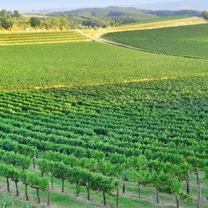
- For the most part of human history, agricultural planning has largely been a system of guesswork. Even where a large set of data has been acquired for a particular piece of land, there are variable factors that we cannot account for and we go with the best fit. GIS can take the guesswork out of the crop planning management with effective collection of soil data and seasonality of topography in line with changing conditions. It allows for precision farming, permitting vineyards for example to maximize yield and quality (3).
- Soil quality is never ubiquitous, even within a single field. If the field slops, drainage and water access can change drastically over just a few feet (because of drainage). Other factors that can affect quality is how much sunlight, shade or rain a certain area gets, the nearness of one side to a road (and therefore the potential pollution level, dust or fragments of artificial material such as rubber and metal) can all affect the quality of a crop (4).
- Mapping is used to find archaeological features in our agricultural land and this has for many years been a successful tool in the heritage industry (5). However, the same types of data will be useful for agricultural science as underlying features can affect the quality and relative height of the crop produced. The same is true of underlying bedrock.
- Identifying new areas to plant crops, either to make existing yields more efficient or simply to continue to provide increasing yields for our growing global population, is presently and will continue to be the biggest challenge for agricultural science. GIS is presently being used as a crowd sourcing project to manage food security and to reorganize crops in the third world (6) to ensure that maximum use is made from the fragile soils in some areas.
- GIS is essential in mapping areas, especially food sources, that are vulnerable to natural disasters such as drought and flood. The World Food Program, the division of the United Nations concerned with food security, is one of the biggest users of GIS data for this purpose (7). They are involved in protecting food supplies by effectively building simple civil engineering projects such as damns, levies and irrigation to protect food supplies
Example Case Studies
Global Warming, Crop Production & GIS
We have a strong idea of how our environment is going to change in the coming decades as weather patterns, soil acidity, deforestation, melting ice caps and other symptoms of the temperature rise will have on our planet. We know how these things might change and affect our food supply, even if the erratic nature of weather systems and climate can only be fully measured while we continue to accumulate more data and make adjustments. We do know that food security will be one of the biggest threats to human civilisation. It has always been an issue with natural disaster, but no disaster is as prolonged - and rarely do we experience permanent effects of those disasters - that the relevant bodies of the world have sought to prepare for those changes.
Increased erosion is another expected result of climate change and this will certainly impact crop production all over the world (8). To this end, there have been many proposals already on how such potential problems can be identified, recorded and acted upon. Several complementary systems will be needed in order to build a full picture of crop production and even produce a simulation of yields in order to aid the potential future picture of the global model; it will use the same data as those presently used by the UN in mapping potential disaster zones for the purpose of plotting relief (7).
Climate change is expected to affect our crop production in several other ways, including but not limited to (9):
- Precipitation changes that affect production (such as drought and flood mentioned above).
- Temperature changes that may either shorten or lengthen the growing season. This may be beneficial for some crops such as wine producing grapes, but for most there will be negative consequences.
Indirect effects include (9):
- Crop prices based on the above environmental changes could skew the overall bulk price. Our food market will change, may not necessarily become unstable, but in some areas core crops that are an essential part of an economy now either become economically nonviable.
- Alternatively, areas where growing a certain crop was once economically nonviable, it may provide a boon for a local economy (12).
What may have once been marginal land for one crop becomes viable for another and vice versa. Economic instability may result. The above two means that GIS will be fundamental in reorganizing what crops we sow and where to maximize land efficiency.
Land Use Planning and GIS
Our growing population needs to persistently look for new areas to build our settlements. Ideally, we would prefer that new towns and cities are not built on prime agricultural land. The problem is that land is one thing we are not manufacturing. Land use presents problems in the developed world, but in the third world where there is a lot of marginal land, it is that much more critical of an issue.
GIS is an essential tool in land planning anywhere in the world (10, p211) to strike the balance between the social demand of the land and its environmental potential capability. Because the infrastructure and money does not exist to properly plan and allow for these factors in emerging economies, and the lack of a history of geographic data, this has proven particularly problematic than in the developed world where it is far more common and increasingly likely a tool for planning such developments (1, p13-14); planning does not just apply to agricultural land (which appears to have remained static), but also to urban development (which has grown) and the amount of land being turned back over to natural use and to preserve their delicate ecologies (which has also increased in the last few decades) (11, p155-6). Protected land is now a matter of public policy in most nations of the world.
Not only do we need to know the quality of the soil, but also to understand the quality of the water. Crops need nutrients and if the soil and geology is favourable to certain crops then we need to know that the water supply and quality is too: industrial action nearby can get into the food supply through irrigation and be absorbed by crops (13). It isn't just standing water agricultural scientists would be interested in, but also sub-surface water supplies, or the “water table” quality.
Related Degrees
Sources
- Longley, P.A., Goodchild, M.F., Maguire, D.J. & Rhind D.W. 2011: Geographic Information Systems & Science (Third Edition). Wiley: Hoboken, New Jersey
- http://www.gislounge.com/use-gis-agriculture/
- http://www.esri.com/esri-news/arcnews/fall13articles/world-class-vineyard-uses-gis-to-finetune-all-its-operations
- http://www.computerworld.com/article/2598510/cgiar.html
- http://www.esri.com/esri-news/arcnews/spring14articles/gis-supports-world-food-programmes-food-security-program
- http://www.sciencedirect.com/science/article/pii/S0304380003001467
- http://www.researchgate.net/profile/Alejandro_Velazquez/publication/222577018_Remote_sensing_and_GIS-based_regional_geomorphological_mappinga_tool_for_land_use_planning_in_developing_countries/links/0deec51aa174894f1c000000.pdf
- http://dare.ubvu.vu.nl/bitstream/handle/1871/22129/landusescanner.pdf?sequence=2
- http://publications.naturalengland.org.uk/file/82046
- Guide to Parasitology - November 19, 2018
- Deserts as Ecosystems and Why They Need Protecting - November 19, 2018
- Conservation: History and Future - September 14, 2018
Related Articles


Featured Article
The Role of Artificial Intelligence in Environmental Sustainability